
Cappadocia is full of beautiful valleys, strange rock shapes, and hidden cave churches—all waiting to be explored on foot.
Whether you want an easy walk through a green valley or a more adventurous trail with tunnels and climbs, there’s a hike here for you.
Best of all, most hikes are relatively short and sweet, making them accessible even if you’re not a hardcore trekker.
In this guide, we’ll take you through the best hikes in Cappadocia, including Red & Rose Valley, Love Valley, Pigeon Valley, and more.
Red & Rose Valley Hike

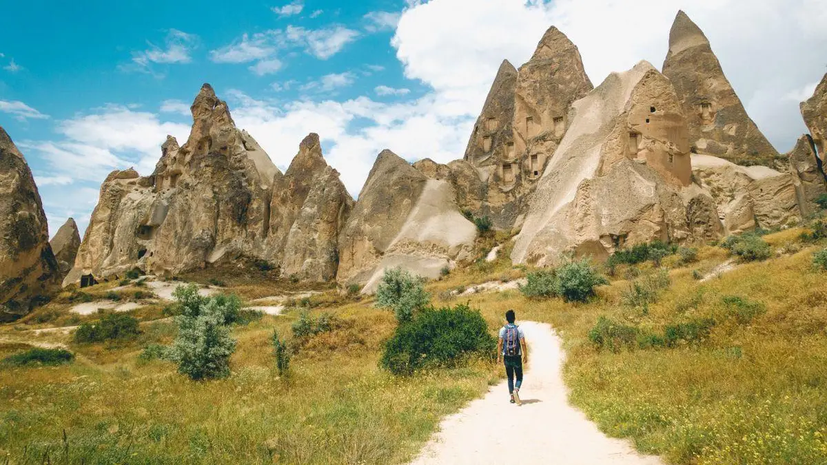
Red and Rose valleys (Kızılçukur and Güllüdere in Turkish) offer what many consider the most beautiful hiking in Cappadocia.
The rocks here have hues of pink, red, and gold – especially stunning toward sunset. Hiking through Red and Rose Valley’s trail network is a bit like being in a maze, but you can do a loop or one-way.
A popular route is to start at the sunset viewpoint above Red Valley (near Ortahisar) and hike down through Red Valley into Rose Valley, ending near Çavuşin. Along the way, you’ll see fairy chimneys, vineyards, and peculiar rock pinnacles.
Don’t miss the hidden rock churches: Üç Haçlı (Three Cross) Church in Rose Valley has cross carvings inside, and Ayvali Church with some frescoes.
Distance & Difficulty: Depending on route, 3–5 km (1.8-3 miles). Some sections have tunnels, so carry a phone light. There are a few mild climbs, but generally moderate.
Tips: Late afternoon gives the best color on the rocks, but bring a headlamp if you risk hiking near dusk. Also, at the sunset end there’s a cafe where you can relax post-hike or even catch the sunset if timed right.
Love Valley Hike

Love Valley is a must-see, and it is named for its uh, “mushroom” shaped fairy chimneys.
The Love Valley hike is relatively easy, an out-and-back trail from the bottom of the valley up toward Uçhisar.
You’ll walk among towering fairy chimneys – some of the tallest in Cappadocia. It’s a very unique landscape, green and fertile at the bottom, with these giant pillars rising around you.
Distance & Difficulty: It’s about 2.5 km (1.5 miles) one-way from the road to the end of the valley. It’s mostly flat, but if you want a workout, you can turn back or scramble up a path towards Uçhisar. It’s easy to moderate if you climb out.
Tips: Start at the Love Valley Panorama (between Göreme and Uçhisar), where you can take photos from above, then drive or walk down to the valley floor entrance. There is no shade here, so a hat and water are essential in summer. There’s no ticket or anything, just an open valley.
Pigeon Valley Hike

As discussed earlier, the trail from Uçhisar to Göreme (or reverse) through Pigeon Valley is scenic and historically interesting—with all those pigeon houses!
As you depart that end, you get lovely views of Uçhisar Castle, and you emerge near Göreme with views of that town.
The path winds through trees and beside small farms, making the Pigeon Valley hike a pleasant, mostly shaded walk for most of the way.
Distance & Difficulty: ~4 km (2.4 miles) one way. It’s a moderate hike – mostly downhill if you go from Uçhisar to Göreme. You will experience a few rocky steps and possibly a bit of mud from recent rain. Easy for regular hikers; take it slow if you’re not used to uneven terrain.
Tips: I recommend doing it from Uçhisar downwards. Stop at the Pigeon Valley viewpoint in Uçhisar first for pictures. The trailhead might be hidden behind some cafes—ask a local if unsure, but usually, you’ll see a sign. Watch for trail markers, sometimes painted markings. Wear proper shoes, as there are grave parts. If hiking in summer mid-day, bring water—while there are trees, it can still get warm.
Check the weather in Cappadocia before heading out for a hike—some adventurers even enjoy hiking in the winter for its snowy, magical landscapes.
Zemi Valley Hike

Zemi is a less-talked-about valley that starts near Göreme Open-Air Museum and loops around to Göreme. It’s a bit wilder and quieter.
On this trail, expect lush vegetation, stream crossings (seasonal), and tall cliffs above you pockmarked with caves. It’s known for spring wildflowers and bird song.
Distance & Difficulty: Around 5–6 km (3-3.7 miles) if you do a round trip. Moderate difficulty – there are a couple of steeper sections and narrow paths along ledges (nothing too scary, but you’ll feel adventurous).
Tips: Because it’s less trodden, parts of the path can be overgrown. Long pants might save your legs from scratches. And it’s wise to have an offline map or notes for the Zemi trail, as signage is minimal. But the serenity is worth it if you want a more off-beat hike.
Ihlara Valley Hike

Okay, Ihlara Valley is a 1.5-hour drive from central Cappadocia, but many do it as a day trip or with the Green tour. It’s a gorge carved by a river, lined with lush greenery and Byzantine cave churches.
The hike is super straightforward—basically, a riverside walk under the shade of trees, passing by small farms and Byzantine chapels carved into cliff walls. However, it feels very different—more oasis-like.
Distance & Difficulty: The full Ihlara route is about 7–8 km (4.3-4.9 miles) from the village of Ihlara to Selime, but many people do a shorter segment – 4 km (2.4 miles) from Ihlara Village to Belisırma village, where there are cafes by the water. It is very easy, flat walking except for the stairs at the start to descend into the valley (about 300 steps down).
Tips: Do this if you have a car or with a guided tour because it’s farther out. It’s great on a hot day since the valley is cooler, and you can even dip your feet in the stream. Don’t miss visiting a few cave churches – they’re marked with signs. There’s one called Sümbüllü and another Agacalti near the start with nice frescoes. Wear comfortable shoes (sneakers fine) and enjoy an afternoon tea by the river when you finish.
General Hiking Tips for Cappadocia
- Always carry water – the dry climate can dehydrate you quickly. A hat and sunscreen are musts in summer; these valleys can bake under the sun.
- Maps.me or AllTrails app offline maps have many of these trails if you want GPS guidance.
- The trails are generally safe, but it’s a good idea not to hike alone, or at least let someone know where you’re going, because paths can be deserted and phone signals might drop in some canyon sections.
- In spring, valleys can be muddy from the rain, and in winter, snow can cover trail markers, but hiking in the snow among fairy chimneys is magical if you’re prepared!
- Bring a small flashlight or use your phone if you encounter tunnels (several valleys have short cave tunnels that are fun to pass through).
- And, of course, leave no trace – carry out any trash and respect any church sites you enter (don’t touch frescoes).